Multimedia projects produced for educational, interpretive, or personal use. QTVR panoramas, images, audio, video, text, maps, links to web pages and slide shows can be incorporated. Interactive public displays can be created that provide information in a user-friendly way. Virtual visits are important at sensitive archaeological sites, as they provide a non-impact way of viewing areas.
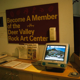
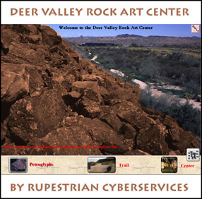
We have developed interactive multimedia CDs for Keyhole Sink (Kaibab National Forest, AZ) and the Deer Valley Rock Art Center (Phoenix, AZ).
|
|
|
Archive research materials using digital scanners and CD-Recordable technology. Scan 35mm slides and negatives, and prints up to 8 1/2" x 14". Various resolutions and file types are available. Data archived to CD-ROM for Mac, Windows, or both. Print photo quality ink jet images up to 17" by 22".
Long life of CD's combined with digital format means your rock art archive will be available, without degradation, in perpetuity.
Images can be stitched together to create mosaics of rock art panels, or as partial or full panoramas to show site and environment. Photographic images can thus be created where direct photography is difficult or impossible.
Long Panel example (275 KB) If QT isn't installed, you may not be able view all of the example.
Interactive QuickTime Virtual Reality (QTVR) panoramas are up to 360-degree views that can contain links to close-up images of areas of interest or links or to other panoramas. Other QTVR movies don't involve panoramas at all.
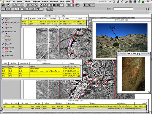
GIS database creation using ArcView which can include spatial data (site) locations using GPS technology. Image catalogs and databases designed for research, management, or personal use. Non-spatial database design and creation using Filemaker Pro is also available.
Geographic Information Systems (GIS) and Global Positioning System (GPS) data combine to provide managers with resource information and the ability to answer research or management questions quickly. Image databases are useful for locating individual sites, images, designs, etc.
We developed a GIS image database and map, with 180 precision GPS locations, for Hueco Tanks State Historic Park (Parks and Wildlife Department, Texas).
In addition to the standard techniques, we bring new digital technology to rock art site recording. Arizona Archaeological Society certified recorder.
Back to Rupestrian CyberServices home page